Welcome to Gerard's Weather Page
Back to my home page
Wyndhamvale Weather Station
Driven by Cumulus Weather Station Software
Wyndhamvale Weather Station For iPhone
| Wyndham Vale Observations | BOM Observations | |
| BOM Thermal Comfort | BOM Forecast | |
| BOM Rain Radar Loop | Weather Map | |
| Recent Satellite Images | Weather Radar Loops Archive | |
| Synoptic Chart | 4 Day Forecast Maps |
Current Nasa Satellite Images
Usually available after 10am and 4pm daily AEST
West of Port Phillip Bay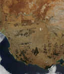
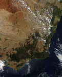 East of Port Phillip Bay
Current Tides
Weribee River Entrance / Williamstown / Port Phillip Heads (Point_Lonsdale) / Bancoora (Breamlea)Another interesting radar java applett from Weatherzone Australia,
You may need to hold the shift key and press reload in your browser when connected to the above sites